Karas
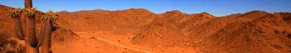
 The Fish River Canyon is 160 kilometres long and 30 wide, and the sidewalls are some 550 metres high ©
 Karas
Karas is the name given to the Southern region of Namibia, and it takes this name from the Karas range of mountains in the south of the region. These, in turn, take their name from the Nama word Kara for the Quiver Tree. The region is bordered by the Orange River in the South, the national border in the East and an imaginary line drawn east west through the town of Gibeon in the north. In the west of the region is the Namib Desert, a restricted area because of diamond mining. The remaining part of the Karas is mainly a semi-arid sunbaked savannah.
In the far south of the Karas is one of Africa's natural wonders, the Fish River Canyon. The Fish River flows into the Orange River in the Ai-Ais and Fish River Canyon Park. The canyon is 160 kilometres long and thirty wide, and the sidewalls are some 550 metres high. The canyon makes an awesome site and is bettered only by the Grand Canyon in the United States of America. There is a road that follows the eastern edge of the canyon for some 25kms that has a series of viewing sites that offer some splendid views of the canyon. The Karas region is famous for its dates and grapes, which grow in the fertile soils along the Riverbanks. In the park is the Ai-Ais Hot Springs Resort, a welcome stopover place for visitors.
The main towns in the Karas are: Oranjemund, Lderitz and Keetmanshoop. Keetmanshoop is a major road, rail and air link and the visitor can see several old buildings that date back to German colonial times. There are two hotels here and a caravan park outside the town. Just a few kilometres to the north of the town is the Kokerboom Forest, a large collection of Quiver Trees which are actually not trees, but a species of aloe, Aloe dichotoma. This forest was declared a national monument in 1955, and some of the trees in this forest are between 200 and 300 years old.
Some 70 kilometres to the north of Keetmanshoop on the western side of the road is an extinct volcano, Brukkaros. This mountain of bare volcanic rock has a crater some 2000 metres across. The western part of the Karas from the Atlantic coast up to a hundred kilometres inland is a restricted area, and visitors may not enter without a permit, as this is the diamond mining area. The mining company De Beers mines some 400kgs of diamonds a year in this area, and to the north of the area near to Lderitz there is a diamond operation offshore, where gravel from the sea bed is vacuumed up and sorted.
On the eastern border with Botswana lies the Kgalagadi Transfrontier Reserve, where the visitor can see a huge variety of animal life, including lion, leopard and cheetah. This area offers a wide variety of different tours and excursions and is a favourite venue for 4 x 4 owners. There are many historical sites to be seen, but these are frequently well hidden and the use of a guide is recommended. Sites include the White Elephant rock art site near Warmfontein and the Lost City of the Yellow Nation, the remains of a red stone citadel only discovered recently.
The people most associated with this region are the Nama people, from which name comes the name Namibia. These people share their cultural roots with the San or Bushman hunters, who have lived in the region for many years, and with the Khoi herder clans from South Africa's Cape Province who were driven across the Orange River during the 17th and 18th Centuries by European settlers.

Grunau Country Hotel
Hotel / Boutique Hotel Accommodation in Grunau
Karas
The Grunau Country Hotel has been a favourite stop over since the 1950's. Our A la Carte Restaurant prides itself in serving only the highest quality of meat which ranges from beef to locally supplied game, lamb and pork. …see more for bookings / enquiries and info.

Villelodge Accommodation
Self Catering Apartment, Flatlet Accommodation in Luderitz
Karas
Villelodge Accommodation offers visitors to Lüderitz with a selection of self catering accommodation to suite your budget. Villelodge Accommodation is a small, family owned establishment that offers quality accommodation at affordable rates. …see more for bookings / enquiries and info.

Obelix Guesthouse
Bed & Breakfast Accommodation in Luderitz
Karas
Obelix Guesthouse provides bed and breakfast accommodation in the historic coastal town of Luderitz in Karas, Namibia. Obelix Guesthouse offers a homely environment, where our guest feel welcome and at ease. Scrumptious home - cooked meals and ample... …see more for bookings / enquiries and info.

Orange House & Aloe Rock House
Self Catering House, Cottage, Chalet Accommodation in Aus
Karas
Both "Orange House" & "Aloe Rock House" self catering units are situated in the small town of Aus and form part of the accommodation complement of the Bahnhof Hotel. …see more for bookings / enquiries and info.

Bahnhof Hotel Aus
Hotel / Boutique Hotel Accommodation in Aus
Karas
The Bahnhof Hotel provides bed and breakfast accommodation in Aus with an onsite restaurant available. The Bahnhof Hotel was initially built in 1906. After extensive renovations in 2005 this Jewel of the Spergebiet has imperturbably grown in size and... …see more for bookings / enquiries and info.

Quiver Inn Guesthouse
Guest House Accommodation in Keetmanshoop
Karas
Quiver Inn Guesthouse provides visitors to Keetmanshoop with a choice of bed and breakfast or self catering accommodation. Quiver Inn Guesthouse welcomes you to the heart of the south of Namibia... …see more for bookings / enquiries and info.

Felix Unite Provenance Camp
Bed & Breakfast Accommodation in Noordoewer
Karas
Felix Unite Provenance Camp offers Bed Only and Bed and Breakfast accommodation in Noordoewer, Southern Namibia. Now also offers guests a choice of 19 cabanas with magnificent river views. …see more for bookings / enquiries and info.