Kalahari & Diamond Fields

Kalahari & Diamond Fields
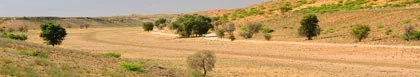
The Kalahari and Diamond Fields region of the Northern Cape borders Namibia, Botswana, the Freestate and the North West Province. The name Kalahari come from the San word meaning 'a place without water'. Some parts of the Kalahari Desert have gone without water for years and are flat featureless plains. But there is usually water beneath the surface, and the flat plains are broken up here and there by mountain ranges, amongst them the Langeberg and Korannaberg ranges. The Kalahari is at the far north-eastern tip of the Northern Province and is a boundless expanse of red earth. The daytime temperatures are extremely hot and the nights can be freezing cold.
In 1866 a young boy names Erasmus Jacobs found a white pebble on the banks of the Orange River close to where it joins the Vaal River. His discovery was to lead to the great South African diamond rush for he had found a diamond that was later to be called Eureka! Shortly after that a huge 83 carat diamond was acquired from a Griqua shepherd by Schalk van Niekerk. This diamond became known as the Star of Africa. Prospectors still sift the gravel beds of the Vaal and Orange rivers for diamonds, though their finds are now few and far between.
Just outside the town of Kimberley in the Diamond Fields region of the Northern Cape, two de Beer brothers had diggings on a farm which they had purchased for £50. By 1872 more than 50000 prospectors had crowded into the little shanty town that later was to become Kimberley. Most of the miners in those days made do with tents or shacks made from wood and corrugated iron ù similar to the informal settlements that can be seen today outside South Africa's big cities. The sites later developed to such an extent that they are now known as the Big Hole and the de Beers Mine. Today Kimberley has become a modern city and is the diamond capital of the world. The city is full of interesting period houses and museums and visitors should not miss a visit to the Big Hole and the Kimberley Mine Museum where there is a replica of the town as it was during the diamond rush.
Several important battles took place around Kimberley during the Anglo-Boer War and the town was besieged by Boer forces. Boer trenches can still be seen in the area and Kimberley's museums house uniforms, weaponry and equipment used during the war.
The Kalahari and Diamond Fields region town of Upington is a beautiful green oasis situated on the banks of the Orange River. The town is ideally situated as a stopover for travelers from Johannesburg or Cape Town heading towards Namibia. The Fish River Canyon, located just across the Namibian border, is a very popular destination for the adventurous hiker. Further to the north along the Botswana border lies the vast desert wilderness of the Kgalagadi Transfrontier Park. These regions can be very hot during the summer months, so visitors are well advised come during the winter months when the temperatures are milder.
The Augrabies Falls National Park is situated about 80 kilometres to the west of Upington in the Kalahari region of the Northern Cape and the Falls ranks among the world's greatest cataracts. During exceptional floods the flow here exceeds that of the mighty Victoria Falls and is considered by many geologists to be the world's most interesting example of weathered granite. The park adjoining the Falls is home to the dassie, also known as the rock rabbit. Resembling a giant guinea-pig, the dassie's nearest relative is probably the elephant.The town of Kakamas is situated just a few kilometers from the Falls and is the perfect stopover for visitors. The town has widespread irrigation schemes and boasts eleven working water wheels. Kakamas has become a major farming area and produces export quality grapes and peaches.

Libby's Lodge
Bed & Breakfast Accommodation in Upington
Kalahari & Diamond Fields
Libby's Lodge, situated in Upington, is ideally suited to both busy professionals and tourists. We offer 10 spacious, uniquely decorated and private double rooms with en suite bathrooms and air conditioning. We also offer self catering facilities. …see more for bookings / enquiries and info.

Upington Inn
Hotel / Boutique Hotel Accommodation in Upington
Kalahari & Diamond Fields
Welcome to Upington Inn, a green oasis in Upington, Northern Cape. The hotel offers 38 newly renovated rooms and a full range of amenities to ensure a comfortable stay for business and leisure travellers. Nestled on the banks of the Orange River... …see more for bookings / enquiries and info.

Broadwater River Estate
Holiday Resort Accommodation in Douglas
Kalahari & Diamond Fields
Broadwater River Estate on the Vaal River near Douglas has a selection of self catering accommodation units, camping facilities and even a house boat! Endless water views, the call of the fish eagle, breath taking sunsets and champagne under a starry sky. …see more for bookings / enquiries and info.

Hemel op Aarde Self Catering
Self Catering House, Cottage, Chalet Accommodation in Orania
Kalahari & Diamond Fields
Orania Hemel op Aarde (Heaven on Earth) offers 4 self-catering accommodation options. A popular tourist destination that receives hundreds of visitors a month. It offers a unique insight into this small town which has has attracted so much media attention …see more for bookings / enquiries and info.

Ouma se Huis
Self Catering House, Cottage, Chalet Accommodation in Grootdrink
Kalahari & Diamond Fields
Ouma Se Huis offers self catering accommodation in Grootdrink in an area known as the Kalahari & Diamond Fields in the Northern Cape. This self catering farmhouse sleeps 8. Ouma se Huis is situated next to the N10 in Grootdrink, between Groblershoop... …see more for bookings / enquiries and info.

Sun River Kalahari Lodge
Bed & Breakfast Accommodation in Upington
Kalahari & Diamond Fields
Sun River Kalahari Lodge provides comfortable, luxurious and affordable Bed and Breakfast accommodation in Middelpos, Upington in the heart of the Green Kalahari right on the banks of the mighty Orange River. …see more for bookings / enquiries and info.

Eden Guesthouse
Bed & Breakfast Accommodation in Kimberley
Kalahari & Diamond Fields
Eden Guesthouse is situated in the suburb of Hadison Park in Kimberley and offers 5 fully equipped double and single bedrooms sleeping 1 to 4 persons. Within 2 - 10 kms of The Big Hole", Airport, Car hire, Flamingo Casino, Absa Park Stadium... …see more for bookings / enquiries and info.


Little Farm Lodge
Self Catering House, Cottage, Chalet Accommodation in Kimberley
Kalahari & Diamond Fields
Little Farm Self Catering Lodge is situated 3.7 km from the edge of town on the N12 Road to Cape Town in a secure, tranquil and country environment and creates a peaceful stay over atmosphere. The Lodge (chalets) form part of a 20ha estate... …see more for bookings / enquiries and info.


Kameelboomkoelte
Self Catering House, Cottage, Chalet Accommodation in Askham
Kalahari & Diamond Fields
Kameelboomkoelte offers 7 self catering chalets, graded 4-stars in Askham, the heart of the famous 'Kalahari Red Dune Route' of the Southern Kalahari and are the result of a dream created by Erick and Nina Meyer. …see more for bookings / enquiries and info.

Orania OppiRantje
Self Catering Apartment, Flatlet Accommodation in Orania
Kalahari & Diamond Fields
OppiRantje is in the Upper Karoo in Orania. It is a luxury well-equipped self-catering apartment with two rooms, one with double bed and the other with two single beds. Lounge-dining room with premium DSTV. WiFi is free and fast. Kitchenette. …see more for bookings / enquiries and info.

Postmasburg Inn
Hotel / Boutique Hotel Accommodation in Postmasburg
Kalahari & Diamond Fields
Postmasburg Inn offers both Hotel and Self Catering accommodation conveniently located midway between Upington and Kimberley, Postmasburg is a welcoming, green town fed by a dam and natural fountains. …see more for bookings / enquiries and info.


Kakamas Hotel
Hotel / Boutique Hotel Accommodation in Kakamas
Kalahari & Diamond Fields
Kakamas Hotel, surrounded by lush green vineyards, sits nestled in the Orange River valley on the outskirts of Kakamas, Northern Cape. Kakamas Hotel is en route to various popular destinations: Augrabies National Park, the Kalahari, Namibia, Richtersveld …see more for bookings / enquiries and info.

Mein Heim Estate Guest Farm
Self Catering Apartment, Flatlet Accommodation in Kimberley
Kalahari & Diamond Fields
Mein Heim is a beautiful farm only 15 minutes drive from Kimberley city centre. Get away from the city and experience the tranquillity of nature. There are four fully equipped units of various sizes. Pets are also welcome by prior arrangement. …see more for bookings / enquiries and info.

Kathu Inn
Self Catering Apartment, Flatlet Accommodation in Kathu
Kalahari & Diamond Fields
Kathu Inn provides self catering chalet accommodation in Kathu. Kathu is the iron ore capital of the Northern Cape Province. Its name means "town under the trees", after the Camel Thorn forest it is situated in. Our self catering accommodation features... …see more for bookings / enquiries and info.
