Postmasburg Accommodation

Postmasburg Inn
Hotel / Boutique Hotel Accommodation in Postmasburg
Kalahari & Diamond Fields
Postmasburg Inn offers both Hotel and Self Catering accommodation conveniently located midway between Upington and Kimberley, Postmasburg is a welcoming, green town fed by a dam and natural fountains. …see more for bookings / enquiries and info.
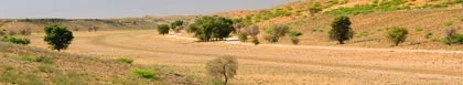
Postmasburg
Postmasburg is located in the Northern Cape province of South Africa, approximately 170 km east of Upington, 67km north of Griquatown and 58km west south west of Danielskuil, and was proclaimed a town on 6 June 1892 and named after the Rev J Postma. Postma was a Reformed Church founding member whose congregation sought a centre of worship. Originally the town was a station of the London Missionary Society called Sibiling, it became a Griqua village with the name Blinkklip. The town achieved municipal status in 1936. The town is complemented by a dam surrounded by lush, green vegetation and sparkling fountains.
Attractions
The Howitzer Gun Civic Centre honours those who lost their lives in WWII. The Postmas Diamond Mine is an old mine which is 45m deep, filled with clear water and well-stocked with fish. And also the Reformed Church, which is a blue dolomite stone building erected in 1908, and the Rev Dirk Postma Statue.
Climate
Postmasburg normally receives about 241mm of rain per year, with most of that rainfall occuring mainly during summer. It receives the lowest rainfall in July and the highest (57mm) in March. The average midday temperatures for Postmasburg range from 17 degrees Celsius in June to 32 degrees Celsius in January. The region is the coldest during July when the mercury drops to 0 degrees Celsius on average during the night.