Hantam Karoo & Upper Karoo
 Karoo National Botanical Gardens ©
  The Aloe "forest" is to be found north of Nieuwoudtville and south of Loeriesfontein, Upper Karoo & Hantam Karoo. © Andy Bytheway, License
 Looking towards Hanover from Trappieskop, Upper Karoo & Hantam Karoo. ©
  Dutch Reformed Church, Church Street, Hanover, Upper Karoo & Hantam Karoo. ©
  Doorn River waterfall situated a few miles north of Nieuwoudtville on the road to Loeriesfontein. The river plunges through an opening in the rock down a precipice of approximately 90 metres. © Damien du Toit, License
 Dutch Reformed Church, Stockenstrom Street, Colesberg, Upper Karoo & Hantam Karoo. © Leo za1, License
 And now for something completely different: Williston Mall, Williston, Upper Karoo & Hantam Karoo. © Mike Peel, License
 Architecture: Victorian villa in Calvinia, Upper Karoo & Hantam Karoo ©
  Dutch Reformed Church, Britstown, Upper Karoo & Hantam Karoo ©
  Corbelled house roof interior. This one remains open, but many are sealed closed. Stuurmansfontein, Carnarvon, Upper Karoo & Hantam Karoo. © Janek Szymanowski, License
 Transnet Heritage Class 6J 645 on Kimberley De Aar Line, De Aar, Upper Karoo & Hantam Karoo. ©
 Hantam Karoo & Upper Karoo
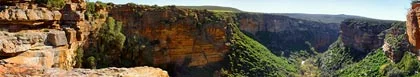
The Hantam Karoo and Upper Karoo regions of the Northern Cape are bounded on three sides by the provincial boundaries and the Orange River. 250 million years ago the Hantam Karoo was a vast inland sea surrounded by primeval forest, lush vegetation and huge mammals. After the breakup of Gondwanaland the region slowly turned into the arid semi-desert we find today. The whole region is renowned for its completely unpolluted skies and the magnificent view of the heavens at night, making it the perfect setting for South Africa's Astronomical Observatory. The area is a region of wide-open plains dotted with rugged mountains and koppies. Wild life and beautiful flora abound, and there are a number of recognized 4x4 trails dotted about throughout the region. The Upper Karoo is more barren than the Hantam Karoo, but both areas explode into brilliant colour with the onset of the summer rains. The Tankwa Karoo National Park, to the west of Sutherland, is the driest place in South Africa.
In the East of the Hantam Karoo and Upper Karoo region the visitor will find numerous deserted towns which had originally sprung up at the time of the diamond rush in and around Kimberly. Diamonds have long since petered out, though there can still be found a handful of persistent miners who spend their time sifting through gravel in the hope of finding that elusive stone. I remember once taking a wrong turn and ending up in a tiny village where the miners were on their stoeps on a late Friday afternoon sipping beer. It was just as if I had stepped back in time by eighty or more years.
Just outside the town of Carnarvon at Stuurmansfontein can be seen some fine examples of corbelled houses. The first corbelled buildings were erected in the early 1800s and served as homes for the early pioneers. They are similar to buildings known to have existed in France, Italy and Portugal and are built with flat stones cemented together with a mixture of straw and mud.
The principal town of the Upper Karoo is De Aar, which has become the central distribution point for the succulent Karoo meat, unique in flavour and quality. The town is an important rail junction for Johannesburg, Cape Town, Port Elizabeth and Namibia. De Aar is famed for its generous hospitality.
A few kilometers to the East of De Aar is a fine example of a Karoo dorp from the past - this is Hanover. This small Karoo town was established in 1854 on a farm belonging to a man called Gous and named after one of his ancestors. When the first houses were built they were compelled to be built directly on the edge of the main road with their gardens at the rear. Owners had to pay a shilling a year tax for the priviledge of having a stoep at the front of the house encroaching the road - this tax is still imposed to this day.
The Hantam Karoo and Upper Karoo town of Victoria West gets its name from Queen Victoria and little has changed since it was first established in 1843. The town is wedged between two mountains and the Ongers River. The town is on the watershed between the West and East coasts of South Africa. To the South of the town is the small Victoria West Nature Reserve, home to a large collection of the riverine rabbit, only found in the central Karoo.
The Karoo is a region of South Africa that should not be missed by the visitor. It is mostly inhabited by sheep and widely scattered acacia trees and shrubs. In the Kalahari Desert can still be found scattered groups of San (bushmen) who have chosen to remain in the desert, unchanged by modern technology.
The Hantam Karoo and Upper Karoo regions in the Northern Cape province of South Africa are known for their rugged landscapes, unique flora, and rich history.
Here are ten things to see or do in these regions:
1. Tankwa Karoo National Park: Explore the stunning landscapes of this semi-desert park, known for its starry night skies, bird watching, and unique plant species.
2. Sutherland: Visit this small town famous for being one of the coldest places in South Africa and home to the South African Astronomical Observatory, where you can tour the Southern African Large Telescope (SALT).
3. Calvinia: Discover the charm of this historic town, visit the Calvinia Museum housed in a former synagogue, and see the giant post box, a well-known landmark.
4. Nieuwoudtville: Experience the "Bulb Capital of the World," especially during the spring wildflower season when the area is blanketed in vibrant colors. The Nieuwoudtville Wild Flower Reserve is a must-visit.
5. Hantam National Botanical Garden: Explore this unique garden that showcases the diverse plant life of the region, including many rare and endemic species.
6. Fraserburg: Wander through this historic town, visit the Fraserburg Museum, and see the Gansfontein Paleo Surface with its ancient dinosaur footprints.
7. Williston: Visit this small town known for its quirky corbelled houses, which are unique to the area. The annual Williston Winter Festival is also a highlight.
8. Loeriesfontein Windmill Museum: Explore this outdoor museum featuring a fascinating collection of historic windmills, a testament to the region's agricultural heritage.
9. Karoo Fossil Braille Trail: Located near Fraserburg, this trail offers an educational experience with information about the region's rich fossil history, including Braille plaques for visually impaired visitors.
10. Roggeveld Mountains: Drive or hike through this mountain range, enjoying the dramatic scenery and tranquil environment. The area is particularly beautiful in the winter when it may be dusted with snow.
These activities offer a mix of natural beauty, cultural heritage, and unique experiences that highlight the charm of the Hantam Karoo and Upper Karoo regions.

Sunset Chalets
Room Only / Limited SC Accommodation in Colesberg
Hantam Karoo & Upper Karoo
Sunset Chalets offers the perfect stop-and-go accommodation in Colesberg in the Karoo, Northern Cape. Colesberg is a very popular stop-over due to its close proximity to the N1 highway, which is the primary route between Cape Town and Johannesburg. …see more for bookings / enquiries and info.

Honeylocust Guesthouse
Bed & Breakfast Accommodation in Colesberg
Hantam Karoo & Upper Karoo
Honeylocust Guesthouse provides accommodation on a bed and breakfast basis in Colesberg in Karoo in the Northern Cape. Honeylocust is a modern, luxury guesthouse in the historic town of Colesberg. Perfectly situated just off the N1 highway... …see more for bookings / enquiries and info.

Die Pophuis Hoekie
Self Catering House, Cottage, Chalet Accommodation in Victoria West
Hantam Karoo & Upper Karoo
Die Pophuis Hoekie provides authentic self catering cottages in Victoria West in the Karoo, Northern Cape. Our self catering accommodation consists of 6 owner-managed, air conditioned, restored Karoo cottages and 3 en suite units - fully walled and... …see more for bookings / enquiries and info.

The Barracks
Bed & Breakfast Accommodation in Colesberg
Hantam Karoo & Upper Karoo
The Barracks offers bed and breakfast accommodation in Colesberg in the Karoo in the Northern Cape. The Barracks (so named as the property was used as barracks during the Anglo-Boer War) was built in 1851 and substantially renovated in 2004. This original …see more for bookings / enquiries and info.

Skitterland Guest House
Bed & Breakfast Accommodation in Sutherland
Hantam Karoo & Upper Karoo
The luxury suites, with private sitting-rooms, are equipped, among others, with a plasma screen TV, M-Net/DStv, fireplaces, heaters, under floor heating and coffee facilities. In each bedroom there are electric blankets, down duvets and woollen... …see more for bookings / enquiries and info.

Calvinia Hotel
Hotel / Boutique Hotel Accommodation in Calvinia
Hantam Karoo & Upper Karoo
Calvinia Hotel offers an oasis in the Karoo town of Calvinia in the Northern Cape. When entering the Calvinia Hotel, visitors are still welcomed with true warm country hospitality. The Hotel offers 25 rooms all with en-suite showers & bathrooms, a Splash …see more for bookings / enquiries and info.