Northern & Eastern Free State

Northern & Eastern Free State
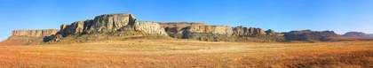
The Northern and Eastern regions of the Free State are bordered in the East by the majestic Drakensberg Mountains and the Lesotho border, and in the North by the Vaal River. In the far east of the region on the Lesotho border and nestled in the foothills of the Maluti Mountains is the 11600 hectare Golden Gate Highlands National Park. While some national parks are noted for their wildlife, the Golden Gate is one of those noted for its natural beauty, and takes its name from the brilliant shades of gold cast by the sun on the majestic sandstone cliffs of the park.
Just to the North of the Golden Gate is the small town of Bethlehem, whose biblical name means "house of bread", an appropriate name for the town that is at the heart of the country's wheat growing region. In fact the whole of the Northern and Eastern Freestate is a most important agricultural area, producing a great percentage of South Africa's maize and wheat.
The small town of Deneysville was proclaimed in 1939 and exists at as a result of the construction of the Vaal Dam, completed in 1938, now the hub of the Vaal Triangle. SA’s 3rd biggest Dam – 12 times larger than Harties. At 32000 hectares in size the Vaal Dam is Gauteng’s main source of fresh, pure water; the main catchment of the crystal waters which flow downstream from Lesotho. Deneysville, the biggest village at the Dam has great heritage from Khoi San caves submersed beneath the water, Voortrekker Graves perfect to explore during starlit, ghost cruises and some of the biggest yachting regattas in Africa. Lake Deneys, now mostly South Bay, one of dozens of waterfronts was home to the southernmost terminal for BOAC's flying boat service from Britain to South Africa during the second world war (SA’s original, international airport)! Deneysville is a main venue for water sports enthusiasts, home to four, major yacht clubs and the NSRI, boat chandlers and working harbours.
Right on the border between the Northern and Eastern Free State and Kwazulu-Natal is situated the charming little country town of Harrismith. Established in 1849 on the banks of the Wilge River, Harrismith gets its name from Sir Harry Smith who was a govenor of what is now known as the Free State. Harrismith is easily recognized when traveling through the region by the large flat topped mountain, the Platberg, which sits just behind the town. The town is the last before making the long climb up the Van Reenen's Pass where the N3 highway cuts through the Drakensberg. There are many reminders of the Anglo-Boer wars in the area.
In the extreme South of the Northern and Eastern region and situated on the Highlands scenic route that follows the Lesotho border lies the small town of Hobhouse. The town is on the banks of the Leeu River and is named after the Anglo-Boer War concentration camp heroine, Emily Hobhouse. This suffragette was so appalled at the conditions in the concentration camps that she started a nursing and welfare service amongst the Boer women. She was so dedicated to her new calling that she called off her wedding -her wedding veil can still be seen on display in Bloemfontein.
A little to the North of Hobhouse is the thriving little agricultural town of Ladybrand, founded in 1867. Ladybrand sits at the base of the Platberg ridge and is an important administrative town in the wheat and sunflower belt of the Freestate. There are many fine examples of sandstone architecture in the town, which lies just a few kilometers from the Caledon Bridge, the main border post between South Africa and Lesotho.
One of the most important towns of the Northern and Eastern Region of the Freestate is Kroonstad which, according to legend, has the distinction of being one of few towns anywhere to be named after a horse, Kroon, which belonged to the prominent Boer leader Sarel Cilliers. Kroonstad is, without doubt, one of the most beautiful towns of the Free State, and is an important centre for the production of maize, wheat, meat, sunflowers, dairy products and wool.

Deelfontein
Self Catering House, Cottage, Chalet Accommodation in Vredefort
Northern & Eastern Free State
Nestled between two high ridges in the heart of the Vredefort Dome World Heritage Site, Deelfontein self catering bush lodges offers activities ranging from hiking and mountain biking to birdwatching and stargazing. …see more for bookings / enquiries and info.

Mountain Rest
Self Catering House, Cottage, Chalet Accommodation in Memel
Northern & Eastern Free State
Mountain Rest is a self catering cottage (sleeps 4) overlooking a dam, situated on a working livestock farm in Memel, Free State. It offers a peaceful breakaway, ideally suited for a small family or group of friends. It is within easy reach of the town... …see more for bookings / enquiries and info.

Lakeview on Vaal @ Vaaldelta Waterfront
Self Catering Apartment, Flatlet Accommodation in Deneysville, Vaal dam
Northern & Eastern Free State
Vaal Waterfront, penthouses, fully equipped, self-catering accommodation at Deneysville, straddling the Gauteng-Free State border, 60 mins from Jhb, 90 minutes from Pretoria. …see more for bookings / enquiries and info.

Sandstone House and Stables
Self Catering House, Cottage, Chalet Accommodation in Kroonstad
Northern & Eastern Free State
Sandstone House (sleeps 7) and Stables (sleeps 2) Guest Farm offers self catering accommodation in Kroonstad, Northern & Eastern Free State. Experience the tranquil farm atmosphere of the central Free State. …see more for bookings / enquiries and info.

Duck Cottage
Self Catering House, Cottage, Chalet Accommodation in Parys
Northern & Eastern Free State
Duck Cottage offers a selection of self catering accommodation on the banks of the Vaal River in Rietpoort, Parys, Free State. Looking for complete relaxation and tranquillity in an African setting you need look no further! …see more for bookings / enquiries and info.

Little Long Creek
Self Catering House, Cottage, Chalet Accommodation in Vrede
Northern & Eastern Free State
Little Long Creek offers self catering accommodation in Vrede in the Free State. The chalet (sleeps 6) with two bathrooms and the adjacent rondavel for two persons (8 persons in total). Located on the outskirts of the Drakensberg mountains... …see more for bookings / enquiries and info.

Ronderus Guest Farm
Self Catering House, Cottage, Chalet Accommodation in Memel
Northern & Eastern Free State
Ronderus Guest Farm provides the perfect self catering accommodation for the adventurer near Memel in the Northern and Eastern Free State. This self catering Guest Farm accommodation (Sleeps 11) is situated between Vrede and Memel. Accommodation consists …see more for bookings / enquiries and info.

Mahem B&B and Self Catering
Bed & Breakfast Accommodation in Memel
Northern & Eastern Free State
Mahem B&B and Self-catering provides guests with a choice of bed and breakfast accommodation and self catering cottage (sleeps 8) accommodation in Memel in the Free State. Our bed and breakfast accommodation: Mahem B&B is a country-style home... …see more for bookings / enquiries and info.

The Rose House
Bed & Breakfast Accommodation in Fouriesburg
Northern & Eastern Free State
The Rose House offers visitors to the Fouriesburg area with self catering or bed and breakfast accommodation. Situated on a 580 hectare farm between Fouriesburg and Clarens on the S325. The main sandstone house was built in 1923 from local sandstone... …see more for bookings / enquiries and info.

JessHil
Self Catering House, Cottage, Chalet Accommodation in Clarens
Northern & Eastern Free State
JessHil is a quaint, self catering sandstone cottage in the picturesque town of Clarens. Clarens is well known as the Jewel of the Free State. JessHil comfortably sleeps 4 guests in two bedrooms with queen beds. …see more for bookings / enquiries and info.

Akzente
Self Catering Apartment, Flatlet Accommodation in Clarens
Northern & Eastern Free State
Akzente is situated in the heart of Clarens, within walking distance of all the galleries, shops and restaurants, but still has a panoramic view of the valley and the mountains of Golden Gate and Lesotho... …see more for bookings / enquiries and info.

MacFarlanes Country Retreat
Self Catering House, Cottage, Chalet Accommodation in Harrismith
Northern & Eastern Free State
MacFarlanes' picturesque setting on the bank of a large lake offers self catering accommodation for up to 12 guests. Warm hospitality and a beautiful countryside await our guests and their pets. …see more for bookings / enquiries and info.

Madrid Farm Cottages
Self Catering House, Cottage, Chalet Accommodation in Clarens
Northern & Eastern Free State
We have three self-catering cottages in the large garden on the farm "Madrid", which has been in the Mousley family for 144 years. The cottages are close enough to the homestead to be very safe but still out of sight of each other. …see more for bookings / enquiries and info.

Golden Cove
Self Catering House, Cottage, Chalet Accommodation in Clarens
Northern & Eastern Free State
Golden Cove is a lovely comfortable and cosy self catering house in the quaint Clarens village and sleeps up to 6 people. There are 3 bedrooms, with 2 queen beds and 3rd bedroom has 2 single beds. Main bedroom has an en-suite bathroom with bath and... …see more for bookings / enquiries and info.

Ongeag Guesthouse
Self Catering House, Cottage, Chalet Accommodation in Clarens
Northern & Eastern Free State
Ongeag is a spacious, fully-equipped, self catering double story sandstone house, surrounded by the mountains of Clarens. Wide balconies integrate the warmth of the house with splendid views of the surrounding scenery. The house is designed to... …see more for bookings / enquiries and info.

Sediba Lodge
Self Catering House, Cottage, Chalet Accommodation in Clarens
Northern & Eastern Free State
Sediba Lodge offers self catering accommodation in Clarens, the "Jewel of the Free State". The Lodges are spacious, well appointed, fully serviced and offer home from home comfort. The view from all the windows is stunning.. …see more for bookings / enquiries and info.

The Barbet Country Cottages
Self Catering House, Cottage, Chalet Accommodation in Clarens
Northern & Eastern Free State
The Barbet Country Cottages are situated on a large farm, 17km from Clarens along the magnificent Maluti route, a beautiful, scenic drive, including our very own 'God's Window', overlooking the vast Maluti Mountain ranges. …see more for bookings / enquiries and info.

Mont Plaisir
Self Catering House, Cottage, Chalet Accommodation in Fouriesburg
Northern & Eastern Free State
Mont Plaisir offers self catering accommodation near Fouriesburg, where you can discover and enjoy the beauty and tranquillity of the Eastern Free State Highlands. 4 self catering options are available. …see more for bookings / enquiries and info.


Camelroc Guest Farm
Self Catering House, Cottage, Chalet Accommodation in Fouriesburg
Northern & Eastern Free State
Camelroc sits between the two Caledon rivers, close to Caledonspoort border post. Its a good base from which to explore Eastern Free State as well as Lesotho. 6 chalets sleeps 8, 6, 2. Hikers Cabin sleeps 16 Main home has three rooms sleeps 6. …see more for bookings / enquiries and info.